
Two basic principle of surveying serves as the cornerstones upon which all other surveying methods are developed. Surveying is the process of determining the relative position of various points on the earth’s surface by measuring the distance between them and creating a map to any reasonable scale. In the blog Basic of civil engineering; a Simple and in-depth guide, we saw the fundamentals of surveying. Here, we will look at the fundamental principle of surveying using diagrams to make it easier to understand.
So, why follow the surveying principle? Is it unavoidable? Let’s see what happens.
What is the principle of surveying?
To understand the importance of the principle of surveying, we should first know the purpose of carrying out surveying. Generally, it is to make measurements of objects on, above, or beneath the ground to show their relative positions on paper. The relative position required is either horizontal, or vertical, or both. Or, similarly surveying is used for the measurement of objects in their horizontal positions.
The principle of surveying which comprises of two main principles are the strategies to get very accurate results. Basically, successful surveying can’t be carried out without obeying the basic principle of surveying. So, let’s sneak into the details of each of the principles that fetch you accurate results in surveying.
Related articles relating to surveying
Fundamental principle of surveying
The main principle of surveying is categorized into
- First Principle of Surveying
- Second Principle of Surveying
First principle of surveying
The first principle of surveying is work from whole to part.
To understand this, we should first know what a control point is.
What are control points?
A control point is a point on the ground or any permanent structure whose horizontal and vertical location is known.
Having this in mind, let’s dive deep into the details of the principle.
In surveying large areas, a system of control points are identified and they are located with high precision. Then secondary control points are located using lesser precise methods. Accordingly, the details of the localized areas are measured and plotted with respect to the secondary control points. This is called working from whole to part.
Importance of the first principle of surveying
To localise the errors
The principle helps to concentrate the errors on the particular points.
To control the accumulation of errors
If the surveying is carried out by adding localised areas errors accumulated and may become unacceptable when a large area is covered.
Moving on to,
Second principle of surveying
Hope you got a clear idea about working from whole to part. Similarly, let us see what the second principle of surveying means.
The second principle states that new stations must always be fixed by a minimum of two measurements (either linear or angular) from fixed reference points. Likewise, linear measurements are horizontal distances measured with chain or tape.
Taking extra care in fixing new control points

Figure shows the various methods of fixing point C with respect to already fixed points A and B by measuring sides, angles, or setting perpendiculars. For fixing new control points (stations) with respect to already fixed points at least two independent processes should be followed.
If A and B are already located control points and with respect to the new control point C is to be located, apart from the minimum measurements required as shown in the above figure, one more measurement should be taken.
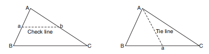
Measuring the lengths of check lines and tie lines will also serve this purpose as shown in the figure below.
So,
what is a check line?
A check line otherwise called proof line is a line joining the apex of a triangle to some fixed points on any two sides of a triangle.
How check lines are used to check accuracy of the framework?
The length of a checkline as measured on the ground should be equal to the length on the plan.
Okay. We are done with check lines. What about tie lines?
What are tie lines?
A tie line joints two fixed points on the main survey lines.
How tie lines help to embed the principles of surveying?
Tie lines generally, helps to check the accuracy of surveying and to locate interior details. The position of each tie line should be close to some features, such as paths, buildings, etc.
So, be happy that you are now savvy in the topic of surveying.
Happy learning!
Comments are closed.